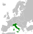
Афаил:Kingdom of Italy (1936).svg

Размер этого PNG-превью для исходного SVG-файла: 450 × 456 апиксельқәа. Даҿа алшарақәа: 237 × 240 апиксельқәа | 474 × 480 апиксельқәа | 758 × 768 апиксельқәа | 1011 × 1024 апиксельқәа | 2021 × 2048 апиксельқәа.
Ахалагаратә фаил (SVG афаил, номиналла 450 × 456 апиксельқәа, афаил ашәагаа: 462 КБ)
| Ари фаил Wikimedia Commons. Афаилтә информациа |
Афаил адаҟьа |
Аԥсахрақәа ахҳәаа
Краткие подписи
Добавьте однострочное описание того, что собой представляет этот файл
Элементы, изображённые на этом файле
изображённый объект аурыс
создатель аурыс
У этого свойства есть некоторое значение без элемента в
правовой статус аурыс
лицензия аурыс
24 лаҵарамза 2013
Афаил аҭоурых
Нажмите на дату/время, чтобы увидеть версию файла от того времени.
| Аамҭарба/аамҭа | Аминиатиура | Ашәагаақәа | Алахәыла | Примечание | |
|---|---|---|---|---|---|
| уажәтәи | 07:53, 12 нанҳәамза 2013 |  | 450 × 456 (462 КБ) | Alphathon | Fixed Dutch polders (see main file) |
| 07:52, 12 нанҳәамза 2013 |  | 450 × 456 (463 КБ) | Alphathon | Fixed Yugoslav-Hungarian border (see main file) | |
| 20:32, 24 лаҵарамза 2013 |  | 450 × 456 (461 КБ) | TRAJAN 117 | {{Information |Description ={{en|1=The Kingdom of Italy in 1936.}} |Source ={{own}} {{AttribSVG|Blank map of Europe 1929-1938.svg|Alphathon}} |Author =TRAJAN 117 {{created with Inkscape}} |Date =2013-05-... |
Афаил ахархәара
Нет страниц, использующих этот файл.
Афаил аглобалтә хархәара
Анаҩстәи авикипедиақәа ари афаил ихархәатәуп:
- Ахархәара am.wikipedia.org аҿы
- Ахархәара bg.wikipedia.org аҿы
- Ахархәара cs.wikipedia.org аҿы
- Ахархәара de.wikipedia.org аҿы
- Ахархәара en.wikipedia.org аҿы
- Ахархәара es.wikipedia.org аҿы
- Ахархәара fi.wikipedia.org аҿы
- Ахархәара hr.wikipedia.org аҿы
- Ахархәара hu.wikipedia.org аҿы
- Ахархәара hy.wikipedia.org аҿы
- Ахархәара is.wikipedia.org аҿы
- Ахархәара it.wikipedia.org аҿы
- Ахархәара ko.wikipedia.org аҿы
- Ахархәара lij.wikipedia.org аҿы
- Ахархәара lld.wikipedia.org аҿы
- Ахархәара mk.wikipedia.org аҿы
- Ахархәара nl.wikipedia.org аҿы
- Ахархәара pl.wikipedia.org аҿы
- Ахархәара pt.wikipedia.org аҿы
- Ахархәара rue.wikipedia.org аҿы
- Ахархәара ru.wikipedia.org аҿы
- Ахархәара sq.wikipedia.org аҿы
- Ахархәара th.wikipedia.org аҿы
- Ахархәара tl.wikipedia.org аҿы
- Ахархәара tr.wikipedia.org аҿы
- Ахархәара uk.wikipedia.org аҿы
- Ахархәара uz.wikipedia.org аҿы
- Ахархәара vi.wikipedia.org аҿы
- Ахархәара xmf.wikipedia.org аҿы
Аметадырқәа
Файл содержит дополнительные данные, обычно добавляемые цифровыми камерами или сканерами. Если файл после создания редактировался, то некоторые параметры могут не соответствовать текущему изображению.
| Краткое название | Countries of Europe |
|---|---|
| Название изображения | A blank Map of Europe. Every country has an id which is its ISO-3166-1-ALPHA2 code in lower case.
Members of the EU have a class="eu", countries in europe (which I found turkey to be but russia not) have a class="europe".
Certain countries are further subdivided the United Kingdom has gb-gbn for Great Britain and gb-nir for Northern Ireland. Russia is divided into ru-kgd for the Kaliningrad Oblast and ru-main for the Main body of Russia. There is the additional grouping #xb for the "British Islands" (the UK with its Crown Dependencies - Jersey, Guernsey and the Isle of Man)

Contributors.
Original Image: (http://commons.wikimedia.org/wiki/Image:Europe_countries.svg) Júlio Reis (http://commons.wikimedia.org/wiki/User:Tintazul).
Recolouring and tagging with country codes: Marian "maix" Sigler (http://commons.wikimedia.org/wiki/User:Maix)
Improved geographical features: http://commons.wikimedia.org/wiki/User:W!B:
Updated to reflect dissolution of Serbia & Montenegro: http://commons.wikimedia.org/wiki/User:Zirland
Updated to include British Crown Dependencies as seperate entities and regroup them as "British Islands", with some simplifications to the XML and CSS: James Hardy (http://commons.wikimedia.org/wiki/User:MrWeeble)
Released under CreativeCommons Attribution ShareAlike (http://creativecommons.org/licenses/by-sa/2.5/). |
| Ширина | 450 |
| Высота | 456 |


